Day 1--June 21, 2013
For the last several months we have prepared for this day. We have planned and shopped and organized. Yesterday, Rob and I drove through Minturn to park the VUE at Camp Hale so we would have wheels to come back on Friday evening.
 |
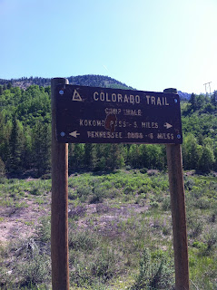
| The CT sign where we parked the VUE. |
 |
| Rob stands at the CT sign for where we will end our hike on Friday. |
The plan was that Sarah and I would hike Segments 4, 5, 6, and 7. Rob would meet us in Copper Mountain on Thursday morning and he and I would continue into Segment 8. Sarah would drive home in the AURA.
We agreed to meet at 7:00 am to finish
packing. Rob would take us to the
trailhead of Segment 4 due to fires in Segment 2. We had so much stuff that after our packs
were full, we had to eliminate items.
Stuff was strewn about the living room as decisions were made. Finally we headed to the car with breakfast
burritos in hand. A picture was taken
and posted on Facebook.
 |
| All packed up, ready to hit the trail. |
We were trail bound! Left the trailhead south of Bailey around 11:00
am. Rob took pictures.
 |
| At the trailhead of Segment 4 outside of Bailey |
 |
| Just about ready to start hiking! |
We saw a woman at the trailhead covered from
head to toe with a large pack. We tried
to interact with her to no avail. Later
we met her as she was resting. We
learned her trail name was Bear Chaser because of an encounter she had on the
Appalachian Trail. She has lots of
hiking experience and lives in Arizona.
We expected to see her again as she said she planned to camp at the
North Fork of Lost Creek at mile 8.2.
Our plans were to camp at Brookside McCurdy at mile 8.9.
Later in the day we met Early Bird, Starbuck,
and Map Man. These three have lots of
experience on the Colorado Trail (CT).
They were doing Segment 4 this weekend and planned to do the segment
near Lake City in early July. We thought
we might see them later as they, too, planned to camp at Brookside McCurdy that
evening.
 |
Walking through one of many aspen forests
|
This section starts at 8280 feet. We camped at about 10,400 feet. That means we climbed about 2120 feet. Whew!
We were a bit naive! Early in our
hike we climbed about 900 feet and stopped for a snack. Then we climbed about 500 feet of a very
rocky jeep road. Strenuous! The data book informed us that we would leave
that road and turn left for a trail that climbed another 600 feet. On this trail we met two guys that were
trying to get to the North Fork of Lost Creek where they planned to camp for
the evening.
We camped near a small
stream because it was getting late (after 7:30 pm) and we were very tired
because we each had only about four hours of sleep the night before. We debated pushing on to get to the North
Fork of Lost Creek like the others, however we decided we needed to stop. We put up our tent on a slope and slid throughout
the night until we found ourselves against some small trees. Sarah had Thai Chicken for dinner; I had
carrots and hummus. We did have cell
service so Sarah sent some texts to say we were OK.


No comments:
Post a Comment